Join The Hiking Forum Now for Free!

Join a Community of Hikers and Backpackers from Around the World. Find and post detailed Trail Reports. Find and discuss the Best Hiking Gear for Your Budget. Become a Better Hiker with the help of Hikers and Backpackers all over the World. Join The Hiking Forum Today, it’s Free!

GPS Unit

Shawn

Administrator
Forum Admin
Forum Moderator
Joined
Jul 6, 2024
Messages
819
Reaction score
553
Location
Metropolis, Illinois
Do you carry a GPS unit hiking?

If yes, what one do you have?

Do you like it? Hate it?
 
Don't carry, Just my iphone coupled with Alltrails has worked great for me.
I bought a Garmin 64-ST to use and had problem after problem with it.

My iPhone apps have always been way easier to use and less problematic than that thing.
 
I have an older Garmin eTrex Vista C, but, like I explained in the "How Do You Navigate Trails Without Cell Service?" thread, I seldom use it anymore. I use a mapping app on my phone called BackCountry Navigator PRO that provides all of the same functions as the Garmin and more, but is easier to use.
 
I've been looking at getting a newer Garmin gps. I'm looking at a really nice one but of course, a rather expensive one.

However, it would also have a PLB attached to it which might be worth the cost.
 
Well, as much as you are out it might be more worthwhile for you than it would for me. I don't know anything about the new Garmin or other brands of handheld GPS units. I just find the phone app to work well for me as a substitute for a standalone GPS. I would like to have a PLB and preferably with the capability to send text messages if there were no cell signal. I can think of some cases where it might be handy for communication in a remote location without a cell signal (vehicle trouble, stuck, just checking in to say I'm OK, etc.). Other than that it would be have it for peace of mind and hope to never have to activate it in an emergency.
 
I'm a fan of Garmin. I have a bike computer by them and my sports watch is by them. I have the Garmin 64st GPS unit but the newer ones have fancier features that I would like mainly because my vision isn't what it used to be. But those units are expensive and I'm a little cheap sometimes lol
 
I just did a quick look at the Garmin website. I suppose you have checked these units out in depth already, so, being somewhat lazy, let me ask a couple questions. Do the newer Garmin units make it easy to import/export maps, tracks, and waypoints directly to/from the units using wifi? Are there sources for maps from third parties that can be imported to the newer Garmins?

My old eTrex Vista C has to be connected up to a computer using a USB cable and the maps and dataset you want to put on it are loaded using the Garmin BaseCamp software which I suppose is now obsolete and replaced with something else. I have the Garmin MapSource software, but don't remember using it. There were several free base and overlay maps available from third parties. You could even make your own custom maps, although I never did that because it looked like a difficult process. I actually liked BaseCamp as a standalone map software for use on my laptop, but haven't used it in a long time because it is easier to use the app on my phone. I remember that one limitation was not being able to display more than one map at a time, so overlays wouldn't work, except there was a way to run a virtual Garmin GPS on the computer and it would trick BaseCamp into thinking there was a GPS attached and for some reason it would then allow multiple maps/layers to display.

I doubt I would be in the market for another standalone handheld GPS, even with built-in satellite communication/PLB capability. Like you said, they are expensive and I'm kind of cheap sometimes myself. I'm sure they have a bit better accuracy and that would be nice to get better waypoints. If I do anything, it will probably be to buy a standalone PLB.
 
Yes it is easy to import and export and actually Garmin comes with a bunch of pre-loaded maps. That's one of the big benefits of Garmin I think over other units -- the preloaded maps.

But they come with that big price, too!
 
Garmin comes with a bunch of pre-loaded maps. That's one of the big benefits of Garmin I think over other units -- the preloaded maps.

But they come with that big price, too!
If (sounds like when 😁) you get that new Garmin GPS/satellite communicator we'll be expecting a full review on YouTube. I can't deny they look nice and have all kinds of specialty maps available if you're willing to shell out the monthly or annual fee for an Outdoor Maps+ subscription. There are certainly advantages that would make them worth the upfront and ongoing cost for some users.

Looking into Garmin more, I found that, much to my amazement, the Garmin BaseCamp software is still being used on PCs by some people for trip planning and waypoint, route, and track management. There is other software available for use with computers to connect to Garmin devices to load and update maps.

Garmin also has a free Garmin Explore app for phones. I don't have it, but it looks like it might be a good free or low cost alternative that provides basic Garmin GPS functions for those who don't want to pay for a standalone Garmin GPS. Unless you pay for an Outdoor Maps+ subscription, you would probably only have access to basic maps. I don't know if it will work with any third party maps. I would guess not because Garmin probably wants to monitize the free app by upselling users to a Outdoor Maps+ subscription to get access to better maps.

The newer Garmin units are much more feature rich than the 20+ year old one I have. Rechargeable vs. using batteries, touchscreen vs. navigation and input through a mini joystick, wifi connectivity vs. USB cords are all big improvements. I'm sure the GPS accuracy is also better with the new generation than older units or phone apps.

All that being true, I don't think I see a new Garmin GPS in my future. I am considering a basic Garmin or other brand PLB/satellite communicator, though. I'm trying to get more into a "be happy with what you have" mindset. I'm nearing retirement. I worry a lot more about the economy than I did 20 years ago.

The BackCountry Navigator app I use does everything I really need GPS-wise. It was a small one-time cost, but there are several free maps that can be saved for offline use and additional maps are available through subscription if you find them useful. There are other good phone apps out there too, some free and some at a small cost. They all have pros and cons. There are minor changes I would like to see in BCN, but it's the map app I'm most familiar with and overall I'm satisfied with it.

Anyone wanting a basic free GPS map app should also look at Peakbagger. Although it is geared to those who do summiting and county high pointing and has a way to record peak ascents, it has a very nice map and GPS capability built in. There are a surprising number of free map sources that can be saved for offline use. It also has the capability to display georeferenced map files like geoPDFs or geoTiffs. All for free.

One thing that has kept me loyal to BCN is the older legacy USGS raster maps of National Forests that I have downloaded like the one below.
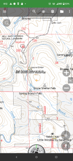
Screenshot_20251010-201230.BackCountry Navigator PRO.png

I like the fact that it shows private and non-FS lands within the Forest boundary with a gray tint. These older maps just have the feel of the USGS and FS 7.5 minute topo quads that used to be issued as paper maps before they switched over to the National Map vector-based maps like below.
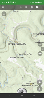
Screenshot_20251011-025612.BackCountry Navigator PRO.png

Don't get me wrong, some of the vector maps are very good and have the advantage of being updated. I'm just partial to the look of the older raster maps.
 
Last edited:
I've looked at Gaia before years ago. I would like the capability to display legacy the maps from a long time back, especially USGS quads. Sometimes they can show historic places, roads, buildings, and former names that no longer are shown on current maps.
 
I've looked at Gaia before years ago. I would like the capability to display legacy the maps from a long time back, especially USGS quads. Sometimes they can show historic places, roads, buildings, and former names that no longer are shown on current maps.
You have to have the premium version of Gaia for it. I do Outside Online + and it comes with that.
 
Back
Top