Garmin comes with a bunch of pre-loaded maps. That's one of the big benefits of Garmin I think over other units -- the preloaded maps.
But they come with that big price, too!
If (sounds like when

) you get that new Garmin GPS/satellite communicator we'll be expecting a full review on YouTube. I can't deny they look nice and have all kinds of specialty maps available if you're willing to shell out the monthly or annual fee for an Outdoor Maps+ subscription. There are certainly advantages that would make them worth the upfront and ongoing cost for some users.
Looking into Garmin more, I found that, much to my amazement, the Garmin BaseCamp software is still being used on PCs by some people for trip planning and waypoint, route, and track management. There is other software available for use with computers to connect to Garmin devices to load and update maps.
Garmin also has a free Garmin Explore app for phones. I don't have it, but it looks like it might be a good free or low cost alternative that provides basic Garmin GPS functions for those who don't want to pay for a standalone Garmin GPS. Unless you pay for an Outdoor Maps+ subscription, you would probably only have access to basic maps. I don't know if it will work with any third party maps. I would guess not because Garmin probably wants to monitize the free app by upselling users to a Outdoor Maps+ subscription to get access to better maps.
The newer Garmin units are much more feature rich than the 20+ year old one I have. Rechargeable vs. using batteries, touchscreen vs. navigation and input through a mini joystick, wifi connectivity vs. USB cords are all big improvements. I'm sure the GPS accuracy is also better with the new generation than older units or phone apps.
All that being true, I don't think I see a new Garmin GPS in my future. I am considering a basic Garmin or other brand PLB/satellite communicator, though. I'm trying to get more into a "be happy with what you have" mindset. I'm nearing retirement. I worry a lot more about the economy than I did 20 years ago.
The BackCountry Navigator app I use does everything I really need GPS-wise. It was a small one-time cost, but there are several free maps that can be saved for offline use and additional maps are available through subscription if you find them useful. There are other good phone apps out there too, some free and some at a small cost. They all have pros and cons. There are minor changes I would like to see in BCN, but it's the map app I'm most familiar with and overall I'm satisfied with it.
Anyone wanting a basic free GPS map app should also look at Peakbagger. Although it is geared to those who do summiting and county high pointing and has a way to record peak ascents, it has a very nice map and GPS capability built in. There are a surprising number of free map sources that can be saved for offline use. It also has the capability to display georeferenced map files like geoPDFs or geoTiffs. All for free.
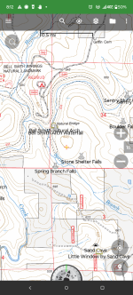
One thing that has kept me loyal to BCN is the older legacy USGS raster maps of National Forests that I have downloaded like the one below.

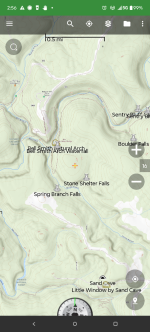
I like the fact that it shows private and non-FS lands within the Forest boundary with a gray tint. These older maps just have the feel of the USGS and FS 7.5 minute topo quads that used to be issued as paper maps before they switched over to the National Map vector-based maps like below.

Don't get me wrong, some of the vector maps are very good and have the advantage of being updated. I'm just partial to the look of the older raster maps.


